This Winter, the Connected Poudre River Trail Leans West From Timnath
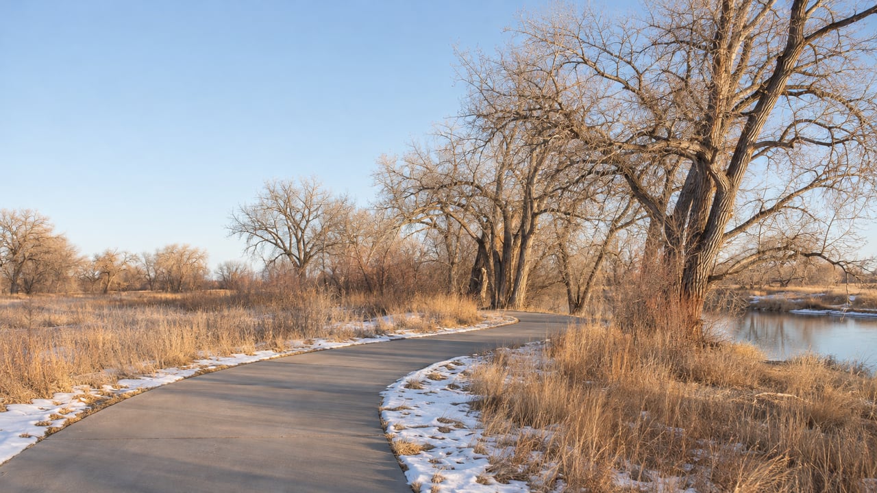
An 83-foot metal bridge now crosses the Greeley No. 2 Canal between south Timnath and north Windsor. It belongs to about a mile of 10-foot-wide concrete that closed the last gap in the Poudre River Trail, and according to the Coloradoan, the segment also includes a pedestrian crosswalk at Larimer County Road 32E. This is the first winter that bridge has carried anyone.
On a map, the trail is now one continuous line. Through December, January and February, the trail you can actually use from Timnath depends on which way you turn. Each agency along the corridor still sets its own winter rules, and those rules put the dependable, cleared mileage on the west side of town.
Larimer County announced the completion on May 22, 2026. The new segment means the Poudre River Trail now offers 45 miles of continuous, paved, multi-use trail from Bellvue, west of Fort Collins, to Greeley. Along the way it passes under I-25 through a pedestrian underpass. The final connector cost $2.4 million. It was funded by Great Outdoors Colorado, with grants from Colorado Parks and Wildlife, the North Front Range Metropolitan Planning Organization and the Colorado Department of Transportation.
The Coloradoan placed the Windsor end of the new piece just northeast of Kyger Reservoir, west of Colorado Boulevard and Weld County Road 13. The Timnath end meets existing trail in the south part of town. The regional celebration, "Connecting Communities," took place on Saturday, June 13, on the east side of Timnath Community Park at 5500 Summerfields Parkway.
That ceremony marked about 50 years of planning by local governments, agencies and funders. Those same agencies still divide the day-to-day running of the trail among themselves.
The Colorado Trail Explorer, known as COTREX, divides its 27-mile Poudre River Trail listing by manager. Greeley handles 11 miles, Windsor 9.4, Larimer County Natural Resources 5.7, and other managers about three-quarters of a mile. The City of Fort Collins runs its own municipal stretch. The Town of Timnath says it maintains 9.9 miles of trail surface, including part of the Poudre River Trail, and lists Weitzel Park as a connection to it.
Every one of those managers decides for itself what happens after a snowfall. The two ends of the trail have published very different answers.
Fort Collins says its park trails "are maintained year round and snow is removed from the trails during the winter months." The city notes that its trails also serve as commuter routes for students and residents.
The Poudre River Trail Corridor, which covers the Windsor, Weld County and Greeley portion, puts it this way:
"The trail is not maintained during the winter. Icy and snowy conditions may exist, especially in shady areas. Travel at your own risk."
The Corridor's own trail alerts page says its updates cover the 22-mile section from Island Grove in Greeley to River Bluffs and Kyger Reservoir in Windsor. Kyger Reservoir is also where the new connector meets the Windsor trail. So, by the Corridor's own description, its winter policy applies almost from the end of the new bridge to the far end of the route.
Timnath's own snow removal page lays out plowing priorities for streets, with Harmony Road and Main Street among them.
West of Timnath, the trail enters a system with a written commitment to clear snow. Fort Collins lists its Poudre Trail at 12.3 miles, running from North Overland Trail to East Drake Road, where it connects to Colorado State University's Environmental Learning Center. The Cache la Poudre National Heritage Area's curated bike tour starts at the Environmental Learning Center and heads northwest past Old Town Fort Collins, Buckingham Park and Lee Martinez Park toward Laporte.
For a sense of distance, a 2025 KUNC ride along the full trail put a Fort Collins stop near Shields Street at about a dozen miles from Timnath Community Park. That makes a ride from Timnath into Old Town and back a realistic winter outing, mostly on trail the city plows.
Even on its cleared trails, Fort Collins warns of thaw-and-freeze ice, especially in shady areas and in early mornings or evenings, and of flooding in low spots and underpasses. Its trails are open the same hours as its parks, 5 a.m. to 11 p.m. The city posts closures through its trail status page, which offers email alerts, and through the NoCo Trail Report map.
| From Timnath | Heading west | Heading east |
|---|---|---|
| Main managers | City of Fort Collins | Windsor, Weld County, Greeley |
| Stated winter policy | Snow removed during winter months | Not maintained during winter |
| Named destinations | Environmental Learning Center, Old Town, Lee Martinez Park, Buckingham Park | Kyger Reservoir, River Bluffs Open Space, Eastman Park, Poudre Learning Center, Island Grove Park |
| Known seasonal closure | None posted for the Fort Collins stretch | Greeley's Narrows, scheduled Nov. 30, 2026 to May 31, 2027 |
The eastern half has the trail's best rest stops. They just come without snow removal. Heading out of Timnath over the new canal bridge, the main named stops come in this order:
The Heritage Area's tour measures River Bluffs to Island Grove at 21.8 miles one way. Restrooms and drinking water are available at Island Grove Park, Eastman Park and the River Bluffs Open Space trailhead, and every parking lot along the Corridor has portable toilets. The Corridor also describes many sections as remote and away from roads. It advises users to go only as far as they can comfortably get back.
Put together, the eastern trail has dependable water, restrooms and parking but no snow removal, and long stretches far from any road. On a clear, dry day after a stretch of sun, River Bluffs and Eastman Park are easy targets from Timnath. After a storm, the Corridor's warning about ice in shady areas is the one to take seriously.
Even on dry days this winter, the full route to Greeley won't be open. The City of Greeley plans to start construction on the Narrows section of the trail at the end of November to fix significant erosion of the trail and riverbank. The project will widen the path from 6 feet to 12 feet, and the affected section will be closed during construction. Greeley places the Narrows east of 83rd Avenue, through Signature Bluffs Natural Area, between sandstone bluffs and the Poudre River.
The project's Speak Up Greeley page lists construction starting November 30, 2026, and the trail reopening May 31, 2027. If that schedule holds, the first connected winter and the Narrows closure will cover almost the same months. A full Timnath-to-Island Grove ride, the trip the new bridge made possible, would wait until about June.
For Timnath residents this season, the eastern trail effectively ends at the closure in Signature Bluffs.
Being close to a trail connection like Weitzel Park or Timnath Community Park is part of what a Timnath address offers. If you'd like to know how your home's location along the Poudre corridor shows up in its value, MCM Collective can put together a valuation built on the details of your street. Request a Home Valuation, and we'll start with the trail at the end of your block.
Stay up to date on the latest real estate trends.
Market Report
More Choice, Fewer Closings, Steady Prices: Northern Colorado Meets a 7% Mortgage Market

Market Report
Rates Cross 7%, Inventory Builds, and the Front Range Splits Into Many Markets


We enjoy being able to provide the level of expert detail and understanding to our clients that we would expect as a client if we were working through the same process. Whether it be going through the home buying process or listing your home, we look forward to working with you soon!
Ready to start a conversation?

Fort Collins 242 Linden St, Suite 216, Fort Collins, CO 80524 Boulder 1470 Walnut St, Suite 201/202, Boulder, CO 80302 Denver 200 Columbine St, Suite 400, Denver, CO 80206